Next: The profile system
Up: The measurements
Previous: The measurements
Contents
Measuring site
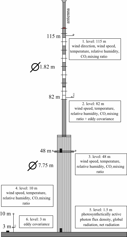
The measurements are carried out on a 117 m tall (137 m with antenna), free-standing
TV and radio transmitter tower at various heights. The tower is owned by Antenna
Hungária Corporation. The lower 56 m is a 7.75 m diameter cylinder made
of reinforced concrete, while the upper 61 m is a steel cylinder of 1.82 m diameter
(Fig. ![[*]](http://nimbus.elte.hu/icons/latex2html/crossref.gif) ).
).
Figure:
The layout of the TV and radio transmitter tower and the instrumentation.
|
|
As shown in Figure ,
Figure:
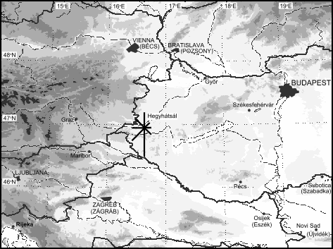
Shaded relief map showing the location of the measuring site,
and the frequncy distribution of wind direction at Hegyhátsál.
|
|
the tower is located in a flat region of western Hungary (46 57' N,
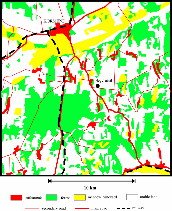
16 39' E), at an altitude of 248 m above sea level. Figure
shows the land use map of the area. The tower is surrounded by agricultural
fields (mostly crops and fodder of annually changing types) and forest patches.
The distribution of vegetation types within 10 km of the tower are as follows:
60% arable land, 30% forest and woodland, 10% other (vineyard, settlements,
etc.). It is not greatly different from the average for the Western Hungarian
Landscape Unit (7,300 km
57' N,
16 39' E), at an altitude of 248 m above sea level. Figure
shows the land use map of the area. The tower is surrounded by agricultural
fields (mostly crops and fodder of annually changing types) and forest patches.
The distribution of vegetation types within 10 km of the tower are as follows:
60% arable land, 30% forest and woodland, 10% other (vineyard, settlements,
etc.). It is not greatly different from the average for the Western Hungarian
Landscape Unit (7,300 km ) or the whole country (93,000 km)
(65.5% arable land, 19.5% forest and woodland, 14% other). The soil type
in the region of the tower is ``Lessivated brown forest soil'' (Alfisol,
according to USDA system). These soils have clay migration and moderate acidity
as well as the more widespread humification, leaching and clay formation (Stefanovits,
1971). The upper layer is generally 10-20 cm thick, and its organic matter content
is 5-8%.
) or the whole country (93,000 km)
(65.5% arable land, 19.5% forest and woodland, 14% other). The soil type
in the region of the tower is ``Lessivated brown forest soil'' (Alfisol,
according to USDA system). These soils have clay migration and moderate acidity
as well as the more widespread humification, leaching and clay formation (Stefanovits,
1971). The upper layer is generally 10-20 cm thick, and its organic matter content
is 5-8%.
Figure:
Land use map of the surroundings of the measuring site.
|
|
Human habitations within 10 km of the tower are small villages (100-400 inhabitants).
The nearest village is Hegyhátsál (170 inhabitants) about 1 km to
the northwest. There is no notable industrial activity in this dominantly agricultural
region. Local roads have mostly low levels of traffic. One of the few main roads
of the region, which carries 3600 vehicles per day on average, passes approximately
400 m to the southwest of the tower. Yet, the site can be considered as rural
in the highly industrialized, densely populated Central Europe.
Next: The profile system
Up: The measurements
Previous: The measurements
Contents
root
2001-06-16