At the highest monitoring level, 115 m above the ground, wind speed (Vaisala WAA15A), wind direction (Vaisala WAV15A) and air temperature/humidity sensors (Vaisala HMP35D) are mounted along with the air sampling tube at the end of a 4.4 m long instrument arm. The arm projects toward north. The analog signals of the meteorological sensors are digitized by means of a 12 bit A/D converter and are transmitted to the data acquisition computer via an RS232 serial link. Proper shielding of the cables and sensors, as well as digitizing of the signals, are essential to avoid picking up of noise in the long cables, which may be caused by the nearby high power antennas. Grounding is also important to minimize the possibility of damage from lightning.
The meteorological instrumentation at 82 m above the ground is similar, but
a wind direction sensor is not installed there. In April 1997 a sonic anemometer
was installed at this level for eddy flux measurements (see Section ![]() ).
).
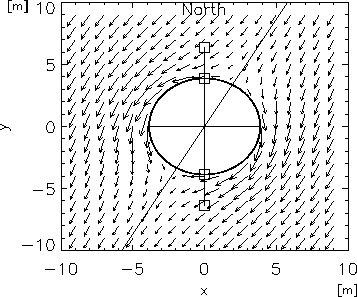
At the 48 m level, the flow distortion caused by the large diameter of the tower
(7.75 m) makes it impractical to build a mounting arm long enough to avoid its
influence on the meteorological instruments. Instead, two 2.5 m long instrument
arms were mounted on opposite (north and south) sides of the tower (Fig. ![]() ).
).
|
|
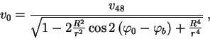
Tower-induced von Kármán vortices can also distort the average wind
vector in the downwind direction, thus only the wind speed value of the anemometer
located on the upwind side of the tower is used for the reconstruction of the
wind speed value. The reconstruction routine uses the measured ![]() and
and
![]() to calculate
to calculate ![]() based on eq.
based on eq. ![]() and eq.
and eq. ![]() as follows:
as follows:
|
The same procedure is applied at 82 m and at 115 m without the possibility to
distinguish between more or less disturbed signal of two anemometers, but the
shadow effect of the tower is not so severe here, since the radius of the tower
is considerably smaller than at 48 m (see Fig. ![]() ).
).
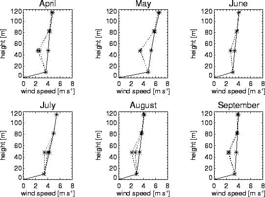
Figure ![]() illustrates the corrected and uncorrected wind speed
data for six months. Comparing to a theoretical log-linear wind profile (Webb,
1970; Stull, 1988; Weidinger et al., 2000) the corrected data give considerably
lower root mean square error than the uncorrected profile and the corrected
data exhibits a more realistic wind profile.
illustrates the corrected and uncorrected wind speed
data for six months. Comparing to a theoretical log-linear wind profile (Webb,
1970; Stull, 1988; Weidinger et al., 2000) the corrected data give considerably
lower root mean square error than the uncorrected profile and the corrected
data exhibits a more realistic wind profile.
In sunny weather, solar heating of the TV tower body may cause overestimates
in the air temperature at the 48 m level, when the wind blows from the SW-SE
sector. The temperature is corrected based on the assumption that during daytime
unstable atmospheric conditions the mean temperature at 48 m should fit the
lapse rate determined by the 10 m and 82 m temperature values. Based on Monin-Obukhov
similarity, an approximate relationship between the difference in temperature
at 10 m and 82 m and the deviation of the 48 m temperature from a linear interpolation
of temperature with height is:
The applied correction procedure preserves the variability of the observed temperature time series at 48 m while correcting the smoothed mean value during the critical time periods. The variability (the difference between the smoothed mean value and the measured values) then added to the adjusted mean value to estimate the real temperature value at 48 m.
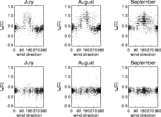
Figure ![]() shows the uncorrected and corrected temperature minus
the values calculated from
shows the uncorrected and corrected temperature minus
the values calculated from ![]() for three months in 1997. The bias
in uncorrected temperature for southerly wind directions is obvious from the
figure. As it is expected, the correction has no effect for non-critical wind
directions. The figure shows that the undisturbed temperature values are somewhat
higher than expected from eq.
for three months in 1997. The bias
in uncorrected temperature for southerly wind directions is obvious from the
figure. As it is expected, the correction has no effect for non-critical wind
directions. The figure shows that the undisturbed temperature values are somewhat
higher than expected from eq. ![]() , so the correction routine adjust
the erroneous values in such a way that the result will exhibit similar behaviour
like the correct ones. The humidity sensor measures the relative humidity for
its actual environmental condition, therefore the measured (uncorrected) temperature
is used for calculation of the absolute humidity.
, so the correction routine adjust
the erroneous values in such a way that the result will exhibit similar behaviour
like the correct ones. The humidity sensor measures the relative humidity for
its actual environmental condition, therefore the measured (uncorrected) temperature
is used for calculation of the absolute humidity.
|
Relative humidity also needs correction since the Vaisala sensors may suffer from zero and span drift. Since span drift can not be recognized easily (L. Haszpra, personal communication), efforts were done to correct for the effect of zero shift. This was attained by substracting a specific value from the relative humidity data determined from long term data selecting saturated (i.e. foggy) conditions. Thus the corrected data can not exceed 100%.
For measurements at 10 m above the ground, a mast was erected about 70 m from the transmitter building and tower. Wind speed, temperature, and humidity sensors are the same as the ones mounted at the tower. Instruments for radiation measurements are mounted at 2 m height on the mast, including a global solar radiation sensor (Kipp & Zonen model CM2), a radiation balance sensor (REBS model Q*6) and a photosynthetically active photon flux density (PPFD) sensor (LI-COR model LI-190SZ Quantum Sensor). Sensors for soil temperature and soil heat flux (Campbell Scientific model HFT-3) have been installed recently near the mast.